.jpg)
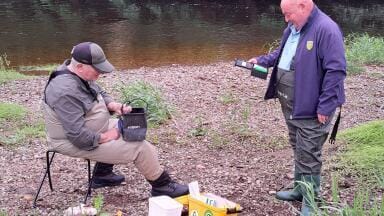
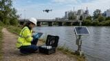
Portable & field testing
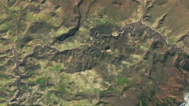
The project has been completely unprecedented in a number of ways, not least as the largest restoration of its kind in US history.
Simultaneously, this scheme managed to pioneer novel methods of comprehensive environmental assessment whilst attending to social justice issues by partnering with local Indigenous groups.
Key concerns included large sediment pulses from drained reservoirs, turbidity spikes and resulting oxygen drops, temperature shocks to fish, and nutrient or pH surges.
They had to track whether salmon and other native fish actually recolonise upstream, whether insects and vegetation rebound, and whether water and soil quality improve.
The monitoring strategy combines automated sensors, field sampling, remote sensing, and community science to capture these outcomes.
For example, turbidity and sediment sensors will run continuously (the official water-quality plan requires real-time turbidity gauging and biweekly sediment sampling during drawdown).
Water chemistry (dissolved oxygen, conductivity, pH, nutrients) and temperature loggers will be deployed along the river and tributaries (with extra sampling during the first big spring flow), to detect any dangerous DO crashes or thermal stress to fish.
Biological indicators will also be monitored: eDNA samples and field surveys will check for returning salmon, steelhead, lamprey and sucker species, and macroinvertebrate counts will gauge river health.
A number of potential threats to the environment had to be monitored as part of the project.
Firstly, sediment release. An estimated 320–600 thousand cubic yards of sediment will erode from J.C. Boyle and other reservoirs.
Short-term spikes in suspended sediment and turbidity (and associated drops in dissolved oxygen) are expected but must stay within safe limits.
To track this, the plan calls for frequent turbidity sensing and periodic sediment-load estimates at USGS gages.
Secondly, water quality. Beyond turbidity, monitoring focuses on nutrient pulses (e.g. phosphorus) and water chemistry.
The new wetlands on irrigated lands (see below) have already cut farm runoff phosphorus from ~5× regulatory limits to near-background in months.
Ongoing water sampling (nutrients, oxygen, pH) will verify that water quality improves as planned.
Thirdly, temperature:. With dam pools gone, river temperatures can fluctuate more strongly.
Networks of temperature loggers are placed in cold-water refuges and spawning streams to detect harmful heating or cooling events.
Tribal biologists are helping map “cool-water areas” to ensure fish have refuges downstream of drawdown pulses.
Lastly, the clearest metric of success is whether fish return.
Salmon, steelhead and endangered suckers are counted using multiple methods.
For example, NOAA/CalTrout installed a sonar camera at the former Iron Gate Dam site and observed over 6,000 salmon and steelhead passing upstream in just two weeks after removal.
On tributaries, video-equipped weirs and carcass/spawner surveys (run by state and tribal crews) tally returning fish.
All agencies and tribes (Yurok, Karuk, Klamath) are sharing data, including PIT-tag tracking, to monitor migration timing and population sizes.
Smaller fish and bugs are tracked by electrofishing and kicknet surveys; an uptick in native insect diversity would signal ecosystem recovery.
Beyond the river corridor itself, outcomes in adjacent land and water are also measured.
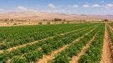
A flagship project is at Lakeside Farms in Oregon, where farmer Karl Wenner converted 70 acres of barley fields into a seasonal wetland.
Instruments and lab tests showed that this wetland quickly soaked up excess phosphorus and sediment.
By early 2023 phosphorus runoff from the farm (which had been ~5× over limits) was filtered down to safe levels in just months.
Biodiversity surveys confirm the change: plant species richness (measured via bee-pollen DNA) doubled within two , and tens of thousands of ducks, geese and 140 bird species now use the wetland.
Critically, two endangered sucker fish species (shortnose and Lost River) returned to breed: of 5,500 juveniles stocked, 50 surviving adults were recovered on sampling, larger and healthier than hatchery controls.
These outcomes are tracked by routine monitoring: water samples (for nutrients and oxygen), fish counts (via seine nets, PIT tagging and genetic testing), and periodic draining of trial ponds to check survival.
Satellite and drone imagery monitor vegetation growth and any algal blooms.
On a farm-tillage side, soil cores show that flooding killed weeds and pests, improving soil organic matter.
His team continues to test soil nutrients and crop health in rotated fields, documenting that wetlands-agriculture rotation reduces fertiliser needs and benefits long-term soil quality.
Similar practices are spreading: the Klamath Tribes and partners have breached levees to reflood 27,000+ acres of drained lake/wetland basins and 14,000 acres of river-estuary habitat.
These projects are monitored via aerial photography and on-the-ground surveys.
For example, after the Klamath Marsh levees were removed, U.S. Fish & Wildlife staff sampled water quality in the reconnected wetlands.
On the technology side, the project uses networks of smart sensors.
Remote dataloggers (transmitting by satellite or local LoRaWAN) stream real-time data on river stage, turbidity, temperature, etc.
Acoustic Doppler current profilers (ADCPs) and optical turbidity probes measure suspended sediment transport as flows ramp up.
Drones equipped with LiDAR and multispectral cameras periodically fly over the channel to map changes in channel shape, shoreline vegetation and sediment plumes.
Mobile field labs (for example, CRREL kits) allow rapid testing of water samples for nutrients and toxins during high-flow events.
Crucially, tribal communities are partners at every step.
The Klamath, Yurok, Karuk and other native tribes have senior water rights and traditional ecological knowledge that guide monitoring priorities.
The Klamath River Renewal Corp. explicitly contracts tribal organisations for key tasks: the Yurok Tribe is leading revegetation on banks, while the Karuk Tribe carries out water quality monitoring and salmon relocation efforts.
Tribal fishery biologists (Klamath Tribes, Yurok, Karuk) co-manage the salmon surveys and have helped design study sites based on ancestral knowledge of spawning grounds.
For example, tribal elders helped select where to place eelgrass and woody habitat structures, and elders’ observations helped interpret eDNA results for sucker presence.
Community monitoring platforms (local volunteers and citizen scientists) are integrating with sensor data, under the mentorship of tribal and agency scientists, to flag anomalies like algal blooms or poaching risks.
Local working groups bring farmers, tribes and agencies together, ensuring all voices inform monitoring goals.
One such group is planning to reconnect a historic lake to the river, and they are designing that project’s water-quality and habitat surveys jointly.
As Yurok Vice-Chair Frankie Myers notes, years of community engagement mean the basin now has enough local capacity to keep restoration on track regardless of federal funding changes.
The immediate monitoring results have been striking, within weeks of dam removal fish cascaded upstream and water quality stabilised faster than many feared.
But ecosystem recovery is a multi-year, even multi-decade process.
The basin’s monitoring network is designed to run continuously, watching for both recoveries (e.g. expanding salmon runs, clearer water) and emerging risks (algal blooms, invasive species).
Information is shared daily among tribes, agencies and scientists so that adaptive actions (like adjusting flow releases or opening additional side channels) can be taken in real time.
In sum, Klamath is becoming a model for how to rigorously measure river restoration.
By tracking multiple metrics and by embedding Indigenous co-management at its core, the project aims to show quantitatively that a freed river can heal itself.
This data-driven, inclusive approach ensures that the Klamath’s promise (renewed fisheries, cleaner water, resilient wetlands) is not just a hope but a documented outcome.
IET 36.2 Mar/Apr 2026


.jpg)