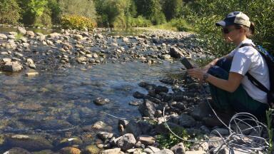
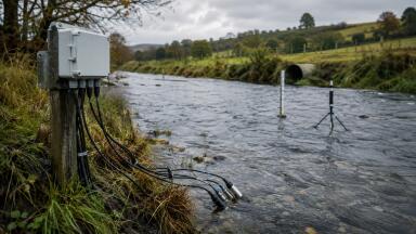
Water monitoring
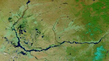
Using official SWOT lake products, researchers were able to estimate volume changes across 1,596 lakes in China, with strong validation against in situ records and a clear improvement in the monitoring of smaller lakes that have often been poorly captured by older satellite approaches.
For environmental monitoring professionals, the significance lies in what SWOT changes operationally. Lake monitoring has long suffered from a basic mismatch: water level and water extent have often been measured by different systems, at different times, and with different limitations.
That has made large-scale volume monitoring difficult, especially where field measurements are sparse and cloud cover, ice or coarse spatial resolution disrupt conventional Earth observation. SWOT begins to close that gap by measuring water surface height and extent together, creating a more coherent basis for tracking storage change.
Lake volume is one of the most useful but hardest-to-observe indicators in water monitoring. It says more than surface area alone, because it reflects actual storage change rather than just shoreline movement. That makes it relevant to water security, drought assessment, flood preparedness, ecological stability and long-term climate response.
In practice, though, volume is difficult to monitor consistently. Ground measurements are limited, especially in remote basins, while earlier satellite methods often forced analysts to combine data from separate sensors and different overpass dates. That introduces timing mismatches and uncertainty, particularly for smaller or more dynamic lakes. The result has been a patchy picture of inland water change, strong in a few well-studied systems but much weaker at national scale.
This is why the China study matters. It is not simply another remote sensing exercise. It tests whether SWOT can provide a more practical large-scale framework for volume monitoring, including water bodies that were previously harder to measure.
The researchers analysed SWOT Level 2 lake products from April 2023 to December 2024 for lakes larger than 0.0625 km² across China. After filtering low-quality observations and removing outliers, they built models linking lake level and lake area to estimate volume change. The result was a national-scale dataset covering 1,596 lakes, with 1,556 derived directly from SWOT and another 40 supported by external bathymetric data.
Validation against reservoir records showed that most errors remained within 10%, with the best case at 3.92%. That level of agreement is important because it suggests SWOT is already usable for practical monitoring, not merely for exploratory research. The study also identified statistically significant volume trends in 583 lakes and found an overall increase of 0.7754 gigatonnes per month across the monitored lake system. Most of that change came from natural lakes, while large and super-large lakes contributed the largest share of the increase.
The seasonal signal was also clear. In eastern China, lake volumes generally rose from winter into summer and then declined from summer into autumn. In plateau and northern regions, ice cover created winter observation gaps, reminding us that even advanced satellite systems remain constrained by environmental conditions. Even so, the mission delivered broad spatial coverage and high observation frequency, especially for smaller lakes.
The key advantage of SWOT is that it measures the shape and height of inland water surfaces in a more integrated way than many previous missions. That matters particularly for volume estimation. If area and level can be captured more synchronously, then water storage change can be inferred with greater confidence.
In the study, lake-level-based estimates proved more stable and accurate than area-based estimates. That is an important finding for monitoring professionals because it suggests that the real breakthrough may not be in seeing more water bodies, but in observing the vertical dimension more reliably. For a long time, lake monitoring from space has leaned heavily on area change because it is easier to extract from optical imagery. SWOT shifts attention back towards water level, which is often the more robust input for volume estimation.
This is especially useful for smaller lakes. They are often overlooked in broad-scale water assessments, yet they can be highly sensitive to climate variability, groundwater interaction and local abstraction pressures. If SWOT improves the monitoring of these smaller systems, it expands the number of water bodies that can be meaningfully included in regional water accounting.
The wider implications are substantial. A mission that can monitor volume change across hundreds or thousands of lakes opens up new possibilities for basin-scale water accounting, drought surveillance, reservoir management and ecological assessment. Instead of relying on sparse ground networks and irregular local reporting, agencies could increasingly work with repeat, standardised satellite-derived storage estimates across very large areas.
That could be especially useful where management depends on seeing cumulative change rather than isolated measurements. Regional declines in inland water storage, for example, often emerge gradually across many lakes and reservoirs at once. A system like SWOT makes those spatial patterns easier to detect. It may also help distinguish between natural seasonal fluctuations and longer structural changes linked to climate, engineering or water demand.
For reservoir managers, the value is also clear. If volume can be tracked more reliably from space, that adds another layer to operational awareness, particularly in systems where in situ data is limited, delayed or unevenly shared. For environmental regulators and hydrologists, it strengthens the possibility of integrating satellite water storage data into broader decision frameworks rather than treating it as supplementary research information.
The study is also careful not to overstate the current state of the technology. Area estimates may still overestimate some lakes and the smallest water bodies remain difficult to capture completely. Large lakes may also require supporting bathymetric data where SWOT alone cannot provide full coverage for volume modelling. Ice cover remains a seasonal barrier in some regions. So this is not yet a complete or frictionless solution.
But that is part of what makes the study useful. It shows that the mission is already operationally relevant while also identifying where future gains are likely to come from. Better processing, improved data releases and stronger integration with bathymetric and hydrological datasets should all increase accuracy and coverage over time.
The larger story here is that inland water monitoring is becoming more volumetric, more synoptic and more scalable. For years, satellite lake monitoring has been strongest at showing surface extent. SWOT pushes the field further towards storage change, which is often the more policy-relevant variable. That brings satellite hydrology closer to the needs of water managers, climate analysts and environmental monitoring professionals who need to know not just where water is, but how much is changing.
In that sense, this study is about more than Chinese lakes. It suggests that lake monitoring is entering a new phase in which national-scale, near-real-time assessments of inland water storage are becoming more feasible. For a monitoring sector increasingly concerned with drought, resilience and system-wide water balance, that is a significant development.
IET 36.3 May


.jpg)