Air monitoring
These remote sensing networks generate continuous streams of Earth Science Information (ESI) on the atmosphere, oceans, land and biosphere.
The technical capability to measure has expanded dramatically over the past half-century. Spatial resolution has sharpened, revisit times have shortened, and sensor integration has improved.
The more strategic question, however, is how the sector defines and communicates the value of that information.
A peer-reviewed study led by researchers at the University of California, Santa Barbara, published in the Proceedings of the National Academy of Sciences, argues that the societal value of ESI remains only partially understood.
The research, led by Casey O’Hara of the National Center for Ecological Analysis and Synthesis, examines how Earth science data are currently valued and highlights significant blind spots in prevailing approaches.
For decades, remote sensing has supported critical environmental and climate-related decisions. It has enabled scientists to understand teleconnections between distant climatic systems, quantify ocean carbon dynamics and map deforestation at continental scale.
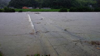
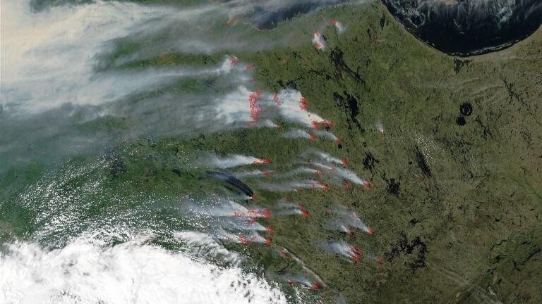
Operationally, Earth observation underpins wildfire forecasting, hurricane tracking, air quality management, agricultural optimisation and flood preparedness.
These applications demonstrate that ESI delivers measurable benefits to society. Yet, according to the study, the way those benefits are assessed is often narrowly framed.
Most valuation studies rely on what is known as a Value of Information framework, in which the benefit of data is defined by its ability to reduce uncertainty in decision-making. Alternatively, researchers apply cost–benefit analysis, calculating avoided damages, improved yields or reduced healthcare costs.
These methods are robust and widely accepted. They have been instrumental in justifying satellite missions and national monitoring networks.
However, they tend to capture only instrumental value, meaning benefits that can be expressed in monetary or directly measurable terms.
The authors argue that this focus risks overlooking relational value. Relational value refers to the ways in which people connect to nature and to each other through environmental knowledge.
Improved wildfire forecasts, for example, may not only reduce property damage but also strengthen public trust in emergency warnings. That trust can increase compliance with evacuation orders, potentially saving lives. Such outcomes extend beyond traditional financial metrics and are difficult to quantify within standard econometric models.
The study reviewed thousands of peer-reviewed publications and ultimately analysed 171 that explicitly applied valuation methods to Earth science data. The vast majority concentrated on instrumental metrics.
Far fewer attempted to assess relational benefits such as community cohesion, cultural identity, place attachment or enhanced wellbeing derived from environmental understanding. The researchers suggest that this imbalance reflects a broader tendency in science to measure what is methodologically convenient rather than what may be most meaningful on the ground.
For environmental monitoring professionals, this critique has practical implications. Instrumentation networks and satellite programmes are typically justified through performance metrics such as accuracy, latency, detection limits and cost efficiency. Funding cases are constructed around avoided losses or improved economic productivity.
While these remain essential, they may not capture the full public value of monitoring infrastructure, particularly as climate impacts intensify and social resilience becomes a policy priority.
The concept described in the study as “pixelating the social” illustrates the challenge. Monitoring systems routinely map canopy cover, aerosol optical depth, sea surface temperature and soil moisture with high precision.
The question posed is whether similarly rigorous approaches could be developed to map social perceptions of risk, safety cultural significance or wellbeing in relation to those same landscapes and seascapes. Integrating ecological metrics with social data layers could reshape how monitoring outcomes are interpreted and applied.
This broader framing also intersects with workforce development. The researchers emphasise that Earth science data are not neutral artefacts. They exist within governance systems, policy debates and community contexts. Future leaders in environmental monitoring may need to understand both remote sensing technologies and socio-cultural valuation methods.
The ability to communicate the multifaceted value of ESI could become as important as technical expertise in calibration or data assimilation.
For the environmental monitoring sector, the study signals a strategic inflection point. The technical frontier continues to advance through higher resolution sensors, AI-driven analytics and integrated observation networks. At the same time, expectations around transparency, public engagement and societal impact are increasing.
Programmes that demonstrate only financial returns may face different scrutiny than those that can also articulate contributions to trust, participation and collective resilience.
Moving beyond money does not mean abandoning quantitative rigour. Instead, it involves expanding the analytical toolbox used to interpret and justify Earth science information.
Surveys, participatory research and qualitative assessments may complement traditional uncertainty-reduction models, enabling a more comprehensive understanding of value.
As environmental pressures mount and monitoring networks expand, defining what counts as value will shape investment priorities and public legitimacy. The capacity to measure the Earth is no longer in question. The emerging challenge is to measure, and communicate, what that measurement truly means for society.
IET 36.3 May


.jpg)