Portable & field testing
Once the domain of high-budget aerospace missions, it is now increasingly accessible to researchers, regulators, and industry professionals.
Its potential to detect, map, and monitor environmental phenomena with unprecedented detail makes it a valuable asset for those charged with observing and protecting the planet.
Hyperspectral imaging was first developed in the 1980s for remote sensing missions led by NASA and other space agencies.
Unlike traditional imaging systems that capture just three spectral bands (red, green, and blue), hyperspectral sensors collect data across hundreds of contiguous spectral bands, often ranging from the visible (400 nm) to the shortwave infrared (2500 nm).
One of the earliest and most influential instruments was NASA’s AVIRIS (Airborne Visible/Infrared Imaging Spectrometer), first flown in 1987.
It laid the groundwork for decades of innovation, demonstrating that materials could be identified based on their unique spectral fingerprints.
Minerals, vegetation, pollutants each reflect and absorb light in ways that can be precisely measured and distinguished.
Through the 1990s and early 2000s, hyperspectral imaging remained largely a research and government tool, used in mineral exploration, agricultural assessment, and military reconnaissance.
High costs and bulky equipment limited broader adoption.
Today, hyperspectral imaging has undergone a quiet revolution.
The sensors are now smaller, lighter, and less expensive, capable of being mounted on drones, field vehicles, or even lab benchtops.
Advances in data processing and machine learning have made it possible to extract actionable insights from the dense, high-dimensional data these systems produce.
At the same time, cloud computing and edge processing have enabled near real-time analysis, a game-changer for environmental monitoring applications that require rapid detection and response.
In environmental science, hyperspectral imaging offers a powerful advantage: the ability to detect what the eye cannot see – not just form and colour, but molecular composition.
Hyperspectral sensors can detect subtle changes in water bodies by measuring reflectance patterns associated with algal blooms, turbidity, or chemical contamination.
From drones or aircraft, hyperspectral imagers can identify gas plumes or aerosols, making it possible to map fugitive emissions or wildfire smoke with high chemical specificity.
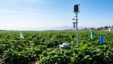
HSI helps evaluate plant stress, nutrient deficiencies, and soil contamination by capturing data on chlorophyll content, moisture, and surface characteristics.
It supports solid waste sorting and landfill surveillance by identifying material types based on their spectral response.
Upcoming satellite missions are expected to generate global HSI datasets to support ecosystem carbon tracking, biodiversity monitoring, and climate change mitigation efforts.
One of the key barriers to widespread hyperspectral adoption is still cost and complexity.
But recent innovations suggest a promising hybrid approach.
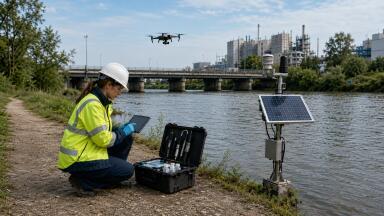
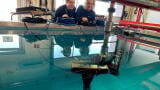
A 2025 study published in the Journal of Applied Remote Sensing introduced a bimodal video imaging platform that combines high-end hyperspectral systems with affordable RGB video.
Researchers from the Rochester Institute of Technology, led by Chris H. Lee, developed a stereo imaging setup using a Headwall hyperspectral spectrometer alongside a GoPro Hero 8 RGB camera.
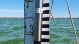
The system was deployed at Lake Ontario to capture dynamic shoreline scenes.
Using machine learning, the team created a model to predict hyperspectral video frames based solely on RGB data, using moments when both systems were active to train the algorithm.
The study demonstrated strong predictive performance in the visible spectrum, where 95% of the water scene was predicted within 2% absolute reflectance.
However, accuracy dropped in the near-infrared, where RGB cameras provide little relevant spectral data.
This hybrid approach shows great promise for expanding the reach of hyperspectral imaging, especially in field settings where deploying full HSI systems continuously may be impractical or too costly.
Future improvements will focus on better field-of-view alignment, enhanced calibration, and more robust prediction models.
For environmental monitoring professionals, such innovations could enable lower-cost, higher-frequency monitoring of aquatic and terrestrial systems, from algal bloom detection to shoreline erosion, using readily available equipment supported by short bursts of hyperspectral calibration.
As hyperspectral imaging continues to migrate from satellites to UAVs to handheld devices, and now blends with conventional RGB video, it stands to become an integral part of how we monitor, manage, and mitigate environmental risks.
The fusion of spectroscopy and imaging delivers a level of chemical and spatial insight that few other techniques can match.
For instrument users across the environmental sector, hyperspectral imaging and its intelligent hybrid successors offer a compelling new frontier: one where the invisible becomes not only visible, but measurable, mappable, and meaningful.
By Jed Thomas
IET 36.3 May


.jpg)