Air monitoring
A recent study led by scientists at Delft University of Technology, working with the Indian Institute of Technology Delhi, has shown that particulate matter concentrations at around 100 metres above ground level in Delhi can be significantly higher than expected during haze episodes.
For India’s environmental monitoring community, the key issue is not simply that pollution is high. It is that the vertical structure of pollution remains largely unmeasured - and therefore poorly represented in models, forecasts, and mitigation strategies.
India has expanded its ground-based monitoring network significantly under the National Clean Air Programme (NCAP). Continuous Ambient Air Quality Monitoring Stations (CAAQMS) provide high-quality surface data in major cities. However, these stations measure what people breathe at street level.
They do not routinely capture what is happening 50, 100, or 300 metres above the surface, where secondary aerosol formation, humidity-driven particle growth, and residual layers can shape the evolution of haze.
Satellite observations provide column-integrated data but lack the vertical resolution needed to understand near-surface layering. Aircraft campaigns are expensive and episodic. The result is a persistent vertical blind spot in urban air quality intelligence.
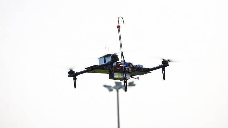
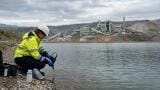
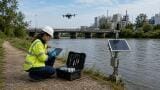
The drone platform demonstrated in Delhi addresses that gap using low-cost PM2.5 sensors mounted on a custom-built unmanned aerial vehicle.
Crucially, the researchers developed a vertical aerosol inlet positioned above the rotor wash to reduce turbulence artefacts, and incorporated a silica-gel dehumidification system to address high humidity, a critical issue in North Indian winter haze conditions.
One of the most significant findings was that model simulations underestimated PM2.5 concentrations during morning haze events. The researchers attribute this partly to a so-called ‘dry bias’, meaning that models do not fully capture hygroscopic growth of aerosols at high relative humidity.
For India’s forecasting systems, this matters. Morning haze episodes often coincide with shallow boundary layers and strong humidity gradients.
If models underestimate vertical concentrations, public health advisories and pollution control measures may be based on incomplete assumptions about pollutant mass and distribution.
For professionals working in dispersion modelling, regulatory reporting, and health risk assessment, the implication is clear: surface-only calibration may not be sufficient to constrain urban air quality models.
The significance of this work lies in scalability.
The study demonstrates that vertical profiling is feasible using affordable components, not only high-end research aircraft.
In the Indian context, this opens the possibility of supplementing existing CAAQMS networks with periodic vertical profiling campaigns, improving validation of chemical transport models used by national and state pollution control authorities, and strengthening urban haze forecasting systems.
It also enables investigation of vertical transport during biomass burning episodes and provides new insight into exposure conditions in high-rise residential and commercial zones. Indian cities are increasingly vertical environments.
Residential towers, office blocks, metro corridors, and flyovers create complex micro-environments where exposure at height may differ from street-level assumptions.
India’s air quality management framework has focused heavily on emission inventories, source apportionment studies, and surface concentration compliance. Drone-based vertical profiling adds a structural dimension to this framework by enabling regulators and researchers to interrogate atmospheric layering directly.
It becomes possible to examine whether secondary aerosols are forming aloft before mixing downward, whether pollution is trapped in residual layers overnight, and whether interventions are targeting the correct atmospheric layer during critical episodes.
In a country where winter inversion dynamics and regional transport strongly influence pollution severity, vertical resolution could materially improve mitigation design and policy timing.
India has a rapidly expanding domestic drone and sensor ecosystem. Integrating low-cost optical particle counters with indigenous UAV platforms could create a cost-effective, locally deployable vertical monitoring solution tailored to Indian climatic conditions.
This aligns with broader digital air quality initiatives, including real-time data platforms, AI-driven forecasting systems, and smart city environmental dashboards.
For instrumentation suppliers and system integrators, the opportunity lies in designing turbulence-resistant sampling systems, improving humidity correction methodologies, integrating drone-derived data streams with regulatory-grade networks, and establishing validation frameworks acceptable to pollution control boards.
The broader shift is conceptual as much as technical. Delhi’s haze problem is not purely horizontal.
It is layered, dynamic, and strongly influenced by humidity and boundary layer physics. Without vertical measurements, models risk systematic bias and mitigation strategies risk targeting only part of the atmospheric system.
For India’s environmental monitoring professionals, this research signals a move from two-dimensional air quality management towards three-dimensional atmospheric intelligence.
Read the full paper here.
IET 36.2 Mar/Apr 2026


.jpg)