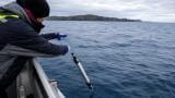
Water testing
Announced just ahead of World Water Day, the MountAInWater project has secured USD 9.5 million from Schmidt Sciences and aims to deliver what researchers describe as the first global reanalysis of mountain water resources using high-resolution physical models, AI and field observations.
For the environmental monitoring sector, the significance is clear: mountain systems are critical sources of freshwater for downstream populations, agriculture, hydropower and ecosystems, yet they remain difficult to monitor consistently across scales.
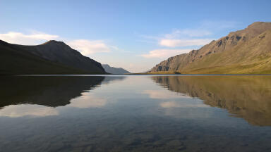
Mountain regions act as natural water towers, storing and releasing water through snowpack, glaciers, permafrost and seasonal runoff. But those systems are being destabilised by warming temperatures, shifts in precipitation, glacier retreat and changing melt dynamics. That makes them increasingly important, and increasingly difficult, to track.
The MountAInWater project is designed to tackle that problem directly. Rather than relying only on broad global models or isolated local studies, it aims to bridge scales: from intensive field campaigns in selected high-altitude observatories to kilometre-scale global modelling of mountain water resources.
For monitoring professionals, this reflects a wider shift already visible across environmental science: the move from fragmented observation towards integrated, multi-source intelligence built from field data, remote sensing, process-based modelling and machine learning.
The project will begin with four 'supersites' in the Canadian Rockies, the Andes, the Pamirs and the Himalaya. These locations will serve as focal points for detailed fieldwork and the collection of high-elevation data on glacier, snow, permafrost and water processes.
That on-the-ground work matters because mountain hydrology is highly nonlinear. Small changes in temperature, wind, snow conditions or precipitation phase can trigger much larger changes in melt, runoff timing and water availability. Traditional large-scale hydrological models often struggle to resolve these dynamics at useful spatial detail.
According to the project team, data gathered at the supersites will be used to improve physically based models of cryosphere behaviour and water fluxes. Those simulations will then be used to train AI systems capable of scaling the analysis up globally, while retaining a much finer spatial resolution than is normally feasible.
For environmental monitoring audiences, this is one of the most interesting aspects of the project. It suggests a practical role for AI as a way of extending the value of high-quality observations and advanced physics-based models across far larger geographies.
One of the project’s central aims is to identify tipping points in mountain water systems. These include critical transitions in glaciers, snow cover and permafrost, as well as nonlinear changes in water fluxes.
That focus is important because many monitoring and forecasting systems still work best when change is gradual and relationships remain relatively stable.
In mountain environments, however, climate impacts can trigger threshold behaviour: precipitation can switch from snow to rain, sublimation regimes can give way to melt-dominated ones, glacier winds can alter local feedbacks and frozen ground can begin releasing water in different ways.
For practitioners, that raises a familiar challenge. Monitoring mountain water is about understanding how the underlying system is changing, and whether past relationships between climate variables and water output can still be trusted.
If MountAInWater succeeds, it could help generate datasets and modelling tools better suited to that reality.
Although the project makes heavy use of AI and advanced computation, it is not framed purely as a modelling exercise. Fieldwork remains central, as does observational data from remote sensing and regional monitoring efforts.
That combination is likely to resonate with monitoring professionals, because it mirrors the way high-value environmental intelligence is increasingly produced in practice.
Satellite data, field campaigns, local observatories and numerical models each have strengths and weaknesses. The real progress often comes from combining them in ways that allow validation, cross-checking and improved spatial coverage.
The involvement of partners including ETH Zurich, Utrecht University, the University of Saskatchewan, the Technical University of Munich, the University of Lausanne, Wageningen University, FutureWater and Climate Adaptation Services points to a consortium built around exactly that sort of integration: cryosphere science, hydrology, ecological impact assessment, remote sensing, AI and water allocation analysis.
After building a global reanalysis, the project will return to what it calls regional 'hotspots of impact', areas where the data suggests major vulnerability or significant change in water availability.
That second step may prove especially relevant for the water monitoring community. Large-scale assessments are valuable, but water decisions are ultimately made regionally and locally.
Utilities, basin authorities, irrigators, planners and conservation bodies need more than global warnings: they need place-based evidence on risk, timing, allocation and adaptation options.
MountAInWater plans to address this through local engagement and through a “Mountain Digital Twin”, an interactive platform intended to help communities visualise climate impacts and test adaptation scenarios.
That places the project within another important trend in environmental monitoring: the growth of digital twins and scenario platforms as decision-support tools rather than just research outputs.
For environmental monitoring professionals, MountAInWater is worth watching for three reasons.
First, it reinforces the growing importance of mountain regions within water security discussions. As climate instability increases, better monitoring of upstream cryosphere and hydrological processes will become more central to downstream planning.
Second, it highlights a methodological shift towards hybrid monitoring systems that combine field observations, remote sensing, physics-based modelling and AI. That is likely to become more common across hydrology and climate-risk work.
Third, it shows how monitoring data is increasingly expected to support not only scientific understanding, but also adaptation planning, stakeholder engagement and resource allocation.
In that sense, MountAInWater is not just a glaciology project. It is part of a broader move towards more predictive, integrated and decision-oriented water intelligence - something that the environmental monitoring sector will need in ever greater supply as climate pressures intensify.
IET 36.3 May


.jpg)


.jpg)