Environmental laboratory
Published over 16 years ago. See the latest and most current information on Environmental laboratory.
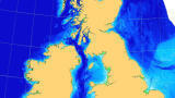
SeaZone (UK) has announced the availability of detailed water depth data for seas around the UK. The company, a subsidiary of the UK Hydrographic Office, has spent 2 years capturing and processing hydrographic survey data to create a unique database of the underwater terrain.
Data on the water depth and seabed surface is essential to many marine activities, such as coastal and offshore engineering, shoreline protection, environment and ecology, fishing, civil security and emergency response planning. Uses include the creation of surface models, volumetric or rate of change calculations, and as input into hydrodynamic or environmental models often used for site selection, route definition and seabed mobility studies.
SeaZone’s Digital Survey Bathymetry extends across the majority of the UK continental shelf and represents the most detailed information of water depth available. It is much more accurate and detailed than depth soundings marked on traditional navigational charts. These charts are created purely for safe navigation and depth data is often generalised and simplified with limited records in areas where there is little or no risk of grounding. SeaZone Digital Survey Bathymetry allows organisations to improve their evidence based decision making and provides better focus, reduction or negation for further costly surveys.
Digital bathymetry data sources are either single-beam or multi-beam surveys, the majority of which were captured by the Royal Navy and the Civil Hydrography Programme. Other data is sourced from harbour authorities and private companies in the engineering, utilities, dredging, and the offshore oil and gas sectors.
Over recent times methods of survey have changed considerably, from individual measurements using a rope (lead-line), through to single-beam acoustic echo-soundings. More modern multi-beam scanning systems such as LIDAR (Light Detection and Ranging) provide much greater detail. This data typically needs to be tidally corrected, positionally verified and audited to ensure that it is delivered in an appropriate standard for wider dissemination. This work has been expertly undertaken by both the UK Hydrographic Office and SeaZone, with Digital Survey Bathymetry available as over 12000 individual datasets in readily readable formats.
SeaZone is investing in further work to deconflict the surveys and provide a best available surface from which to base better informed decisions.
IET 36.2 Mar/Apr 2026


.jpg)