Environmental laboratory
Published over 5 years ago. See the latest and most current information on Environmental laboratory.
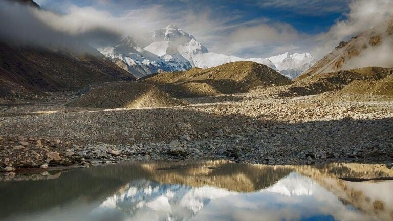
The tallest mountain in the world has just grown another two feet, according to official estimates agreed upon by China and Nepal for the first time. The two countries have disagreed over the exact measurements of Mount Everest for the best part of two centuries, but last month they finally came to an understanding that the peak is precisely 8,848.86 metres (or 29,031.69 feet) above sea level.
While the movement of the tectonic plates beneath Everest does mean that the mountain can grow incrementally each year, it cannot simply shoot up by two feet overnight. Instead, the discrepancy in the figures is due to recent advances in the techniques used to measure the mountain’s height, rather than any growth spurt it may have experienced itself.
Geographically, Mount Everest stands within the borders of both China and Nepal, meaning the two countries both claim ownership of it. Problematically, the pair have been unable to concur on the exact height of the tallest mountain in the world for over 170 years. The Chinese have maintained that it stood at 8,844.38 metres above sea level, while the Nepalis believed it was slightly taller, at 8,847.73 metres.
However, a breakthrough was made last year when the two officials finally agreed upon an exact measurement for the very first time in history. Their shared measurement of the peak is around one metre higher than both previous estimates, with the scientific community pointing to advances in technology as the reason behind the new official record.
Arriving at the new measurement was no easy task. First of all, knowing where to begin the measurement from is subject to debate, since continuous online water monitoring is required to determine a definition of the term “sea level”. That’s becoming more relevant by the day, as the climate crisis continues to play havoc with sea levels on an increasingly regular basis.
Next, there are the logistical challenges of ascertaining the distance between sea level and the peak of Everest. To do so, both countries sent a team of surveyors to scale the summit, armed with cumbersome GPS equipment. After spending months analysing and discussing their results, the Chinese and Nepali authorities finally announced the new measurement simultaneously on live television.
“It is a historic day today,” remarked Bidya Devi Bhandhari, the President of Nepal, in an open letter to his Chinese counterpart, Xi Jinping. “Indeed, completing this important task with our own human resources and technical capacity is a significant achievement. While sharing this happy moment, I extend my sincere congratulations to the governments and peoples of both Nepal and China.”
Any intrepid explorer intent on conquering the mountain will now have to tackle two more feet of ascent in order to claim they have beaten it – but the record still stands for those who have already scaled the previous measurement. However, there was some dismaying news last month when it was learned that microplastics have reached the top of Mount Everest, meaning human pollution has now infiltrated the deepest point of the planet and the tallest, too.
IET 36.3 May


.jpg)