Air monitoring
Published over 10 years ago. See the latest and most current information on Air monitoring.
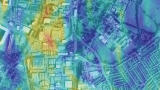
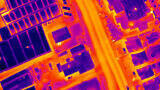
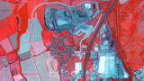
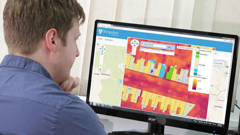
A night time thermal imaging project is helping Shropshire Council improve energy efficiency and affordable warmth levels for residents and businesses across the county. Undertaken by aerial mapping company, Bluesky (UK), and funded by the Department of Energy and Climate Change (DECC), the thermal survey used specialist sensors to accurately record heat loss measurements from buildings at night. The resulting colour coded heat loss maps are being made available online, via the council’s website, for residents and business owners to check the performance of their homes and business premises.
Malcolm Price, Shropshire Council’s Cabinet member responsible for housing, said: “Aerial thermal imaging provides a unique opportunity to collect up to date and accurate measurements for every property within the target zone. The data allows us and our partners to identify specific properties at risk of fuel poverty, and better focus our resources and advice to vulnerable households.
“The easy to use colour coded maps are also an effective engagement tool in the promotion of energy efficiency and affordable warmth projects. Links to further energy efficiency advice, guidance and the availability of financial assistance will also be made available through our website.”
Thermal surveys, such as the one commissioned by Shropshire Council, are carried out during the winter months, in the early evening and after sunset, to capture the widest variations in temperature that can occur as a result of poor insulation or excessive energy consumption. Bluesky uses a ‘microbolometer’ thermal camera specifically designed for airborne surveying and ideal for use in aircraft flying at night. It allows measurements of heat loss from property roofs to be recorded with higher precision and more consistent results than other systems currently in use in the UK.
The resulting data was delivered to the council ready for use in their Geographic Information System and online mapping portal. By combining the Bluesky data with other sources of intelligence, such as demographic profiles, housing stock surveys and benefits claims, the council hopes to be able to better focus resources and advice to vulnerable and at risk households.
Shropshire thermal maps are also available on the website, where householders can check the performance of their own property and even compare this with similar properties nearby. Households highlighted as having excessive heat loss – shown as yellow in the map window – can then access further advice and guidance from the council’s Keep Shropshire Warm webpage where they can apply for various types of financial assistance to help them improve their property’s energy efficiency and affordable warmth.
IET 36.2 Mar/Apr 2026


.jpg)