Weather monitoring
Flood warnings depend on accurate precipitation data. So do reservoir operations, hydrological models, and the climate records used to assess how rainfall patterns are shifting. Getting that data right depends on sensors that work reliably, in the worst conditions and the most difficult locations, precisely when it matters most.
Conventional precipitation gauges have two problems. The data they produce runs consistently low, because the mechanical collection process loses precipitation to wind, evaporation, and freezing. That bias runs through every network and every model built on it. Correction factors help, but they are inconsistent across networks and cannot fully compensate.
The second problem is coverage. In many of the locations most vulnerable to flash floods and debris flows, such as remote mountain slopes and exposed catchments, there are no gauges at all. Conventional gauges require regular on-site maintenance, which makes remote and exposed sites too costly to equip. When intense rainfall hits an unmonitored slope, there is no data to trigger a warning.
Research published in Weather, the journal of the Royal Meteorological Society (Dunn et al., 2025), confirms that losses range from a few percent under favourable conditions to nearly half of actual precipitation in demanding ones, and for snow or exposed sites, recorded amounts can fall below one-third of what actually fell. As the frequency and intensity of extreme precipitation events increases, the cost of that gap grows with it.
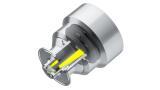
“For over a century, precipitation gauges have measured too low. Not because of how networks were designed or operated. Because of a physical limitation built into the technology itself, one that the entire field had learned to work around. Our engineers thought differently, and proved it with RM60,” said Anne Jalkala, EVP, Weather, Energy, and Environment at Vaisala.
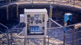
Vaisala has launched PRECICAP® Radar Precipitation Sensor RM60, the first precipitation sensor built to solve both problems at network scale. Where conventional gauges collect and count rainfall mechanically, RM60 uses patented radar technology to measure each falling raindrop, snowflake, and hailstone individually as it passes through the air. Because RM60 does not rely on catchment, it is not subject to the physical losses that affect conventional gauges. That means more detailed data: not just how much rain fell, but how hard it was raining, what type of precipitation it was, and the size distribution of the drops. It requires no cleaning, no calibration, and no field visits throughout its service life, and its design eliminates the wind errors that affect conventional gauges without any additional infrastructure.
RM60 delivers better ground truth for weather radar networks, and richer inputs for forecast models and hydrological simulations. The result is more complete, more trustworthy data for the forecasters, hydrologists, and infrastructure operators who depend on it, and ultimately for the communities whose safety depends on their work.
IET 36.3 May


.jpg)