Air Monitoring
Launch of historic air quality data for the UK
Sep 26 2018
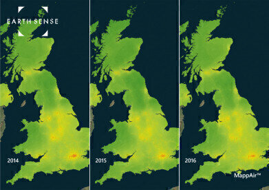
EarthSense are pleased to announce the launch of historic annual datasets of the entire UK at an unprecedented 100m resolution. Delving into the archives, EarthSense have reconstructed air pollution concentrations for 2014, 2015, 2016 and 2017 for every 100mx100m plot of land in the UK.
These datasets draw on DEFRA’s network of air quality stations, in addition to a wide array of road layout and vehicle density information, to ensure the most accurate possible statistics.
For the first time, these datasets allow a detailed view of the impact of road layout changes and major programmes to manage air quality over the last 4 years. In addition, trends are available to highlight places in the UK where the air pollution issue is either improving or degrading.
The data is available as a fundamental mapping product and can be converted into bespoke reports by EarthSense or can be used as part of a value-added service by our customers.
Come and visit EarthSense on stand 3 at AQE for more information about historical MappAir data!


Digital Edition
IET 34.2 March 2024
April 2024
Gas Detection - Biogas batch fermentation system for laboratory use with automatic gas analysis in real time Water/Wastewater - Upcycling sensors for sustainable nature management - Prist...
View all digital editions


Events
Apr 30 2024 Melbourne, Australia
Apr 30 2024 Birmingham, UK
May 03 2024 Seoul, South Korea
May 05 2024 Seville, Spain
May 06 2024 Minneapolis, MN, USA