Environmental Laboratory
New Thermal Mapping Service
Mar 17 2012
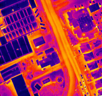
Energy inefficient households in the UK are being pinpointed and directly targeted for improvement with a new end to end thermal mapping service from Bluesky (UK). Specialist thermal sensors mounted on survey aircraft record the heat loss from houses on cold, clear winter nights. Poorly insulated homes are identified and matched to the correct address. Bluesky process the information all the way through to the production of bespoke, targeted marketing material.
These targeted, easy to understand marketing materials highlight inefficient homes in an easy to understand map form. The postcard or other mailing document shows how the house compares to other properties in the same street and is sent directly to the homeowner. Commissioned by local authorities, energy companies or home improvement businesses these marketing campaigns inform homeowners that they may benefit from extra insulation and provide suggestions as to how to go about increasing insulation and reducing carbon emissions.
Bluesky has already captured thousands of square kilometres of thermal survey data across England on behalf of many local authorities, social housing providers and even police forces who use the survey results to identify properties used as cannabis factories. The latest commissioned surveys are being undertaken on behalf of a London Borough, the majority of local Councils in Surrey as well as Rushmoor Council in Hampshire and an urban regeneration company in Northern Ireland.
The thermal surveys will be captured by Bluesky using a ‘microbolometer’ thermal camera; a system specifically designed for airborne surveying and ideal for use in aircraft flying at night. Combined with an advanced navigation and positioning system and improved sensor control and user interface Bluesky’s new generation thermal mapping system allows measurements of heat loss from property roofs to be recorded with higher precision and more consistent results than other systems currently in use in the UK.
Thermal surveys are flown during the early evening, after sunset, in order to capture the widest variations in temperature that can occur as a result of poor insulation or excessive energy consumption. The data can be produced ready for use in an organisation's Geographical Information System (GIS) or Bluesky can produce ready to be delivered marketing documents highlighting actual heat loss values for individual properties.


Digital Edition
IET 34.2 March 2024
April 2024
Gas Detection - Biogas batch fermentation system for laboratory use with automatic gas analysis in real time Water/Wastewater - Upcycling sensors for sustainable nature management - Prist...
View all digital editions


Events
May 13 2024 Munich, Germany
May 15 2024 Lund, Sweden
May 15 2024 Frankurt-am-Main, Germany
May 20 2024 Columbus, OH, USA
May 21 2024 Lagos, Nigeria