Environmental Laboratory
3D Aerial Maps Help Model River Pollution
Jul 28 2010
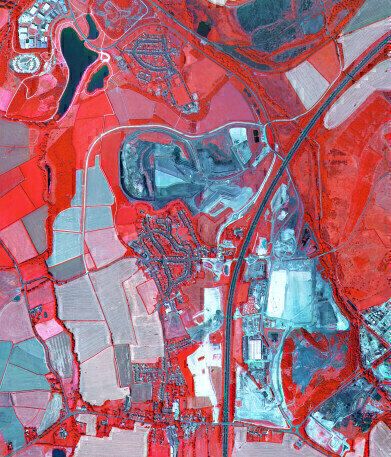
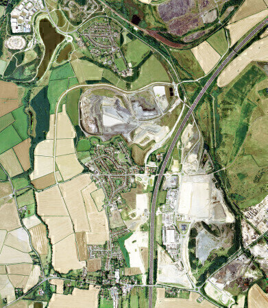
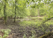
Computer generated 3D visualisations are being used to help study river pollution in the UK of the River Doe Lea. The research project, carried out by the National Trust with partner institutions the University of Sheffield, Environment Agency, Natural England and other consultancies aims to develop a multi-targeted catchment management strategy. Airborne remote sensing data, supplied by Bluesky (UK), was used as part of a PhD study carried out within the project. The digital aerial photography, Colour Infrared Imagery (CIR) and photogrammetrically derived digital height models were used to model the flow of agricultural pollutants and assess the diffusive effect on the landscape.
Results from the project ‘Modelling Catchment Landscapes Potential to Mitigate Diffuse Pollution from Agriculture’ were recently presented at an international conference on Catchment Science organised and attended by members of CatSci a multidisciplinary research programme in catchment science funded by the European Commission under the Marie Curie Early Stage Training Fellowship scheme.
Nataliya Tkachenko, author of the research project commented, “The primary aim of the study was to develop an interactive landscape model, which would give the possibility to evaluate mitigation options in scenario context and open opportunities for participatory GIS applied to agriculture. This model is novel in the aspect of geotargeting of mitigation options within the real landscape, where solutions can be downscaled to the finer elements.
Evaluation of landscape processes in the context environment is highly complicated process, which requires substantial amount of data input on various temporal and spatial scales. Both 3D visualisation, CIR derived indicators and temporal data are powerful source of input information.”
She continued, “Being able to represent and visualise the countryside in all aspects was essential for the accurate modelling of the mitigating effects of the landscape on the agricultural pollutants studied. The Bluesky data was available off the shelf and in a format and specification suitable for use in our geographical information system (GIS) and image analysis software.”
The Bluesky data supplied to the University of Sheffield for this study is part of the GeoPerspectives product range. GeoPerspectives offers nationwide coverage of high resolution aerial photography and Colour Infrared imagery as well as highly accurate, photogrammetrically derived Digital Terrain Models (the earth’s surface excluding buildings and vegetation) and Digital Surface Models (the earth’s surface including buildings and vegetation).
Bluesky is also able to provide ultra detailed LiDAR (Light Detection and Ranging) data and services covering the majority of England and Wales including all major urban centres, coastal areas and flood plains.
Digital Edition
IET 34.2 March 2024
April 2024
Gas Detection - Biogas batch fermentation system for laboratory use with automatic gas analysis in real time Water/Wastewater - Upcycling sensors for sustainable nature management - Prist...
View all digital editions


Events
May 13 2024 Munich, Germany
May 15 2024 Lund, Sweden
May 15 2024 Frankurt-am-Main, Germany
May 20 2024 Columbus, OH, USA
May 21 2024 Lagos, Nigeria