Environmental Laboratory
Can Drones Save Our Coasts?
Jun 27 2016
The Seven Sisters are an iconic landmark of natural beauty located on the East Sussex coastline of England. Recently, a sizable chunk of their chalkstone composite fell into the seas below, prompting fears about further rock-falls in the future and how this could endanger the public.
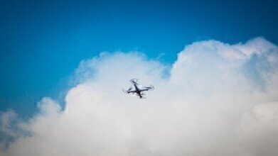
Predicting landslides and collapses is a difficult business, due to the inaccessibility of the sites in question, the absence of hard data on such rock-falls in the past and the erratic nature of their occurrence going forward. However, a trial run undertaken at Telscombe Cliffs in the south of the country is seeking to provide the most comprehensive data on our cliffs to date, using the aid of unmanned aerial vehicles (UAVs), better known as drones.
Prediction relies on constant mapping
An inventory of events is imperative if we are able to make any sort of accurate predictions as to the likelihood of rock falls in the future. This data will not only help us determine when collapses are likely to happen, but also assess potential risk to people and animals living in the area and take appropriate action to avoid it.
With 53% of the English and Welsh coastline comprised of cliffs and shelves, it’s no easy feat to keep track of all of the erosion taking place around the nation all of the time. Traditionally, 3D models of the UK’s cliffs have been obtained via terrestrial laser scanning (TLS), which uses a network of high-tech lasers to detect landslides from several hundred metres away, capable of sensing rocks as small as the size of a fist.
Though this system is quite accurate in its ability to monitor collapses, maintaining a comprehensive picture of the entire coastline is incredibly difficult. Not only is TLS very expensive in terms of the quantity and price of the apparatus involved, but it also involves a significant amount of manpower in pulling all of the results together.
Drones as a feasible alternative
One alternative to TLS is digital photogrammetry. Using the mobility of camera-mounted drones, researchers can access great swathes of the country’s coastline in one fell swoop and collate all of the data together in one, high-precision map of the area in question.
The attractiveness of this option is its relative affordability in comparison to TLS and the ability to access remote areas with the drones. Drones are often used for such operations – they have also recently been utilised to monitor temperatures among the Siberian permafrost, a region which is so cold that it’s inaccessible to humans.
Indeed, the only real limitations on the drone’s mapping capabilities are its battery life and its camera memory capacity. The pilot project, conducted at Telscombe Cliffs just east of Brighton, ran for an eight-minute flight and collected sufficient data to create a map comparable to that produced by TLS. Repeat runs over many years could help to build up a comprehensive picture of the nation’s coastline, thus improving our ability to predict landslides and erosion and better safeguard the public.


Digital Edition
IET 34.2 March 2024
April 2024
Gas Detection - Biogas batch fermentation system for laboratory use with automatic gas analysis in real time Water/Wastewater - Upcycling sensors for sustainable nature management - Prist...
View all digital editions


Events
May 20 2024 Columbus, OH, USA
May 21 2024 Lagos, Nigeria
May 23 2024 Beijing, China
May 23 2024 Beijing, China
May 29 2024 Beijing, China