Air Monitoring
Tools for Mapping Greenhouse Gas Emissions in Urban Environments
Oct 04 2016
Author: LI-COR Biosciences on behalf of Li-Cor Inc
In urban environments, greenhouse gas emissions are complex and numerous. Automated instruments make detection and mapping easier. Automated mapping is an important tool for climate research, leak detection and evaluating threats to human health.
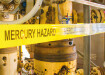
First reported October 23, 2015, a wellhead blowout and methane leak at the Porter Ranch natural gas storage facility in southern California forced thousands of residents from their homes. This event highlighted the need for effective leak detection and characterization of methane plumes, especially in populated areas.
On December 21, 2015, The South Coast Air Quality Management District (SCAQMD) began using LI-COR’s LI-7700 Open Path Methane Analyzer-mounted on a moving vehicle-for automated monitoring of fugitive methane emissions. At the Porter Ranch site, they repeatedly detected significant increases in CH4 concentrations exceeding 50 ppm when measured from a road 1.5 miles away from the leak.
This article examines tools for measurement and mapping of carbon dioxide (CO2), methane (CH4) and water vapor (H2O) concentrations and/or fluxes in urban environments. Mapping integrates spatial data with concurrent observations of greenhouse gas concentrations and/or fluxes. City planners, researchers, and developers can use these data when designing industrial, energy, transportation, and residential infrastructure. The data may also be used for regulatory and emergency response purposes. Direct measurements of methane and other greenhouse gases are important not only for detecting fugitive emissions such as leaks, but also for addressing climate change and urban air quality.
Mapping CO2 Concentrations
Urban environments have been shown to have ambient CO2 concentrations much higher than surrounding rural areas, resulting in domes of CO2-enriched air. These CO2 domes tend to show variation on time scales as long as seasons or as short as days, and can track changes in community behavior. It has been suggested that while CO2 at typical ambient concentrations poses little or no direct health risk to humans, it may still serve as a valuable air quality indicator in urban environments. Increases in CO2 concentration are correlated with increases in ground level ozone and particulate matter, and may actually enhance ozone production.
CO2 domes can be characterized by sampling CO2 concentrations at heights of a few meters or less above the ground using a portable gas analyzer along transects across the area of interest. By sampling CO2 concentrations concurrent with location data, a clear picture of how ambient CO2 concentration varies across the landscape can be built.
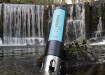
LI-COR® Biosciences makes a turnkey solution for measuring and mapping CO2 concentrations. The LI-8100A Automated Soil Gas Flux System—equipped with the optional CO2 Mapping Kit—can continuously measure and record atmospheric CO2 concentrations at a fixed height while walking or driving. An integrated GPS unit provides location data....
Digital Edition
IET 34.2 March 2024
March 2024
Gas Detection - Biogas batch fermentation system for laboratory use with automatic gas analysis in real time Water/Wastewater - Upcycling sensors for sustainable nature management - Prist...
View all digital editions


Events
Apr 17 2024 Guadalajara, Nexico
Apr 18 2024 Shanghai, China
Apr 22 2024 Hannover, Germany
Apr 22 2024 Marrakech, Morroco
Apr 23 2024 Kuala Lumpur, Malaysia